
US weather: Weak La Nina to allow for Christmas heatwave as temperatures to surge
Americans could be spending Christmas in T-shirts with a freakishly warm winter on the way.
A hangover from the summer heatwave will push temperatures above average across much of the country.
High temperatures will be driven by warm ocean waters, partly responsible for recent hurricanes, and a La Nina cooling of the Pacific.
La Nina, the counterpart of a strong El Nino warming over the past year, can jolt the jet stream and change the Pacific storm season.
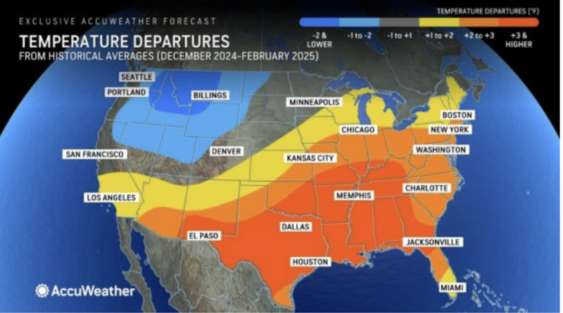
AccuWeather senior meteorologist Paul Pastelok said: “On the heels of one of the warmest summers on record in the United States, our long-range experts are forecasting a mild winter with above-historical average temperatures across three dozen states.
“We will have a weaker La Nina for most of this winter, and there could be changes in the storm track during the season.
“It could dive farther south into California, which can result in periods of mild Pacific air moving across the central and eastern US.”
La Nina follows El Nino, which causes Pacific waters off the coast of Peru to warm as winds change direction.
US LATEST:
Donald Trump left red-faced after losses at Scottish golf course DOUBLE to £1.4m‘Embarrassing and offensive!’ Pro-Palestine activist mistakenly rips down Greek flag in Israel mix-upBill Clinton’s immigration comments BACKFIRE on Democrats as Republicans make new attack ad
Both phenomena can impact the weather across the globe, including in Africa, Asia and Australia.
In the US, it can drive cooler conditions to the north, but much warmer weather across southern states.
Pastelok said: “Between December and February, the warmest areas of the country, compared to the average, will be from the South, central southern Plains states through the Mississippi Valley, up through the Ohio and Tennessee valleys.
“A combination of La Nina keeping the storm track over the northern part of the country most of the winter, above-average water temperatures in the Gulf of Mexico, and mild Pacific air occasionally flowing into the Plains and East will limit the potential for cold air to have a sustained presence across the southern US.”
But ‘significant’ snow will remain a threat across northern and eastern regions, which will catch the rough end of La Nina.
The Midwest and the surrounding Great Lakes could see an ‘uptick’ in snowfall this year, Pastelok warned.
He said: “Most areas in the Northeast are expected to receive more snow this season than last winter.
“An uptick in snow is also likely across parts of the Midwest, including Minnesota, Wisconsin and Michigan.”
Jim Dale, US meteorologist for British Weather Services and co-author of ‘Surviving Extreme Weather’, said: “A La Nina would affect the weather this winter in the US.
“The north may experience colder-than-average conditions while it would be warmer to the south.
“There is the risk of some quite significant periods of snow across northern states.”
Meanwhile, experts are closely watching the tropical Atlantic for signs of another potential storm.
Two ‘disturbances’ in the ocean basin show signs of strengthening on their journey westwards.
Weather Channel spokesman Chris DeWeese said: “The National Hurricane Centre is monitoring two areas in the Atlantic for possible tropical development.
“The next name on this year’s list will be Nadine.”