UK weather: Storm Eowyn assault is first of month-long barrage in Britain
Storm Eowyn’s 100mph assault will be the first in a month-long barrage with Britain on the storm roller-coaster into spring.
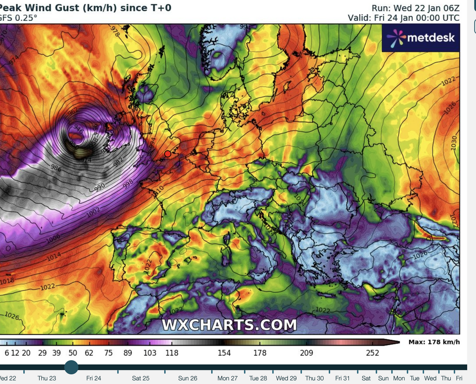
Severe gales, flooding downpours, snow and even tornadoes will strike widely today as the biggest storm of the season barrels in from the Atlantic.
After a lull on Saturday, another storm on Sunday threatens more wind and rain with little let-up through next week.
Long-range outlooks show more storms driven by the jet stream are possible through the rest of winter.

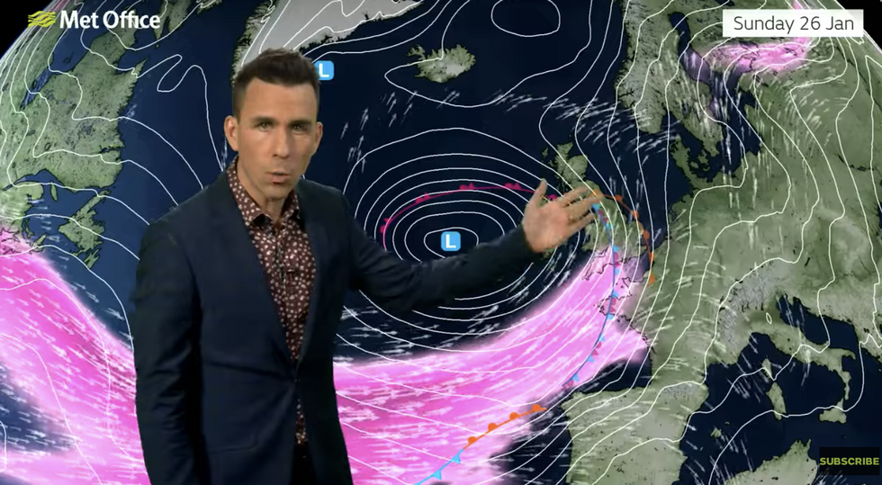
Met Office meteorologist Aidan McGivern said: “There will be more blustery weather throughout Sunday into Monday and potentially beyond that as the weather stays very unsettled.
“If we skip forward to Tuesday, we can see that a low is still sitting to the west and northwest of the UK, and this is the most likely weather pattern for Tuesday as it is looking very unsettled.
“It is likely to stay unsettled throughout next week.”
Flying debris, falling trees and toppling power lines through the next 37 hours have prompted warnings for widespread severe disruption.
Eowyn, the first named storm of the year and the fifth of the season, will strengthen ‘explosively’ as it approaches the UK.
LATEST DEVELOPMENTS:
- Red warning in effect as Britons told to ‘stay indoors’ amid record-breaking 114mph winds
- Anderson demands DEATH PENALTY returns after Rudakubana handed ‘unduly lenient’ 52-year sentence
- ‘Pork barrelling a living!’ Lowe skewers human rights lawyer over outrageous illegal migrant demand

A huge drop in central pressure called ‘explosive cyclogenesis’ will turn the storm, the second this year to warrant a Red government warning, into a deadly ‘weather bomb’.
The Met Office has issued a raft of weather alerts including a ‘danger to life’ from 100 mph winds, although independent forecasters warn gusts could be higher.
Mr McGivern said: “Eowyn moves onto the cold side of the jet stream and that allows it to deepen intensely and rapidly in a process known as explosive cyclogenesis.
“It is likely to bring a spell of disruptive, damaging and even dangerous winds as it moves through.
“A very nasty swathe of strong winds is likely to move into Northern Ireland, into the Isle of Man and into North Wales, northwest England and southwest Scotland, and these winds are likely to be very, very worrying.”
Met Office deputy chief Meteorologist Mike Silverstone added: “Storm Eowyn is expected to bring very strong winds and widespread disruption on Friday.
“The strongest wind gusts are likely to be felt across parts of Northern Ireland, southern and central Scotland, northern England and northwest Wales, where exposed sites could get gusts in excess of 80mph, possibly 90mph, which has the potential to cause impacts for those in these areas.
“The focus for the highest winds shifts to Scotland on Friday night into Saturday.”
Britain’s weather has come under the influence of an extreme cold snap hitting the United States.
Temperatures of minus 20C meeting warmer weather near the Gulf of Mexico is boosting the jet stream on its path to Britain.

The jet has turned into a storm conveyor belt, ‘spinning up’ and firing out low-pressure cyclones lurking in the Atlantic.
This pattern is expected to continue into the start of next week and possibly into February.
Global weather drivers including cooling of the eastern Pacific and sweeping patterns of rainfall over the Indian Ocean could also boost the wind and rain.
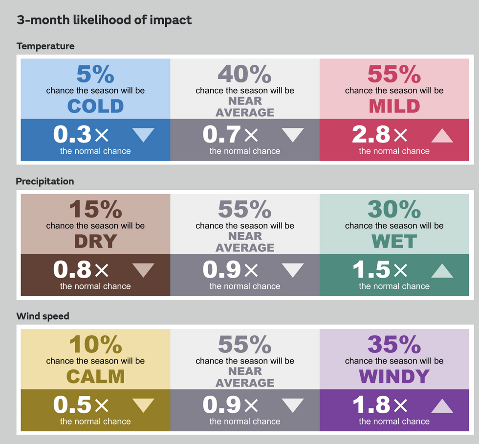
The Met Office’s three-month contingency outlook warns of an increased chance of wet and windy weather into March.
It is more likely to be mild than cold, it says, with only a 10-per cent chance of a ‘calm’ end to the season.
A Met Office spokesman said: “Global weather patterns can affect the UK weather during the coming season.
“The likelihood of the period being windy is greater than normal, implying stormy spells of weather are more likely.”

