US weather forecast: Storm-hit America on ‘critical fire’ alert as plume of heat sweeps in
Storm-hit America is on alert for another dose of misery as hot, dry winds sweeping in from the tropics drives a spate of wildfires.
‘Critical fire’ conditions have been declared by the National Weather Service (NOAA) across Texas, Nebraska, South Dakota, and Iowa as humidity drops and temperatures rise.
Thermometers are forecast to hit 80F as a plume of warmth floods into southern states including Arizona and New Mexico, over the coming days.
Strong winds whipped up by a barrage of ‘life-threatening’ storms have triggered an ‘elevated fire danger’ –Red Flag Warning –which is expected to last through Thursday.
A spokesman for the NOAA said: “A Red Flag Warning means that critical fire weather conditions are either occurring now or will shortly.
“A combination of strong winds, low relative humidity, and warm temperatures can contribute to extreme fire behaviour.
“Elevated fire danger is confined to the Texas Big Bend on Wednesday, followed by portions of the central Plains on Thursday.”
It comes as America braces for 135mph tornado winds, torrential rain and hail carried by a bout of unusually potent storms crossing the country.
Cold air from the north clashing with a tropical plume from the Gulf of Mexico has fired the jet stream to drive an ‘intensifying’ storm system westwards ahead of the weekend.
The NOAA warns of very heavy rain across central regions and tornado strikes to the south.
Eastern states will be in the firing line at the end of the week for torrential downpours and the risk of floods.
The Great Lakes and the Midwest will feel the brunt of the storm at the end of the week, with the Mid-Atlantic and the ‘virtually the entire northeast’ to be hit on Friday.
The NOAA has issued tornado watch warnings across Mississippi and Louisiana, with high surf warnings in force in surrounding states.
A separate flash flood warnings is inn force in Mississippi, Arkansas, Louisiana and eastern Texas.
A spokesman for The Weather Channel said: “These storms have already produced life-threatening flash flooding, large hail and wind damage.
“People should watch for strong tornadoes, large hail, damaging winds and heavy rain.
“A few tornadoes and damaging winds will be the main threats on Thursday.”
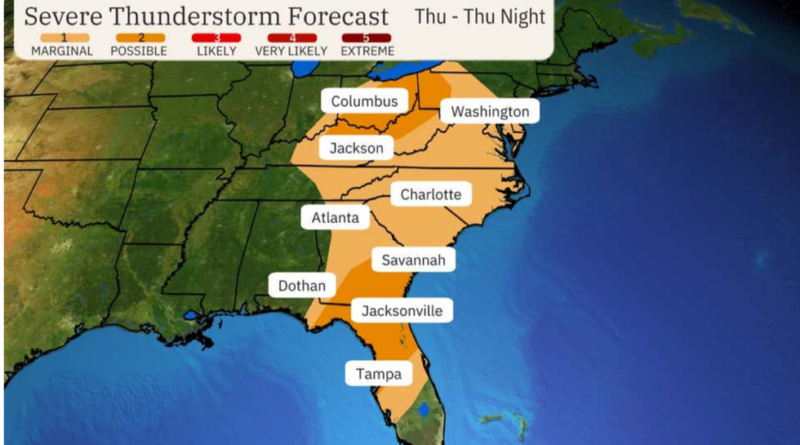
Weather Channel meteorologist Chris Dolce added: “Severe weather will continue to spread east ahead of a cold front through parts of the South and East through Thursday, producing tornadoes, destructive wind gusts and serious flash flooding.
“On Thursday, parts of the East will be at risk, but there will be a greater risk of severe weather in Ohio, northeast Kentucky and western West Virginia, and southern parts of Georgia and South Carolina into northern and central Florida.”
Meanwhile, to the far south, the main alert is for fire hazards as scorching winds scour parched land.
Jim Dale, US weather correspondent and meteorologist for British Weather Services, said: “We are going to get heat coming up from the south, most probably into southern Texas, and southern states, Florida and Georgia.
“These areas, and into the Midwest have been dry with very low humidity, and with the warm air that is coming up from the south, and high temperatures, there is going to be a risk of fires.
“However, it is important to point out that the main risk of wildfires comes from arson.
“This is what triggers the fires, then winds combined with the dryness of the ground and the dryness of the environment cause them to spread.”

